Correct the Map Initiative Launches in Africa
Why this is here: Africa’s coastline stretches over 30,000 kilometers, supporting fisheries, shipping, offshore energy, and critical ecosystems that form one of the largest and least developed blue economies on the planet.
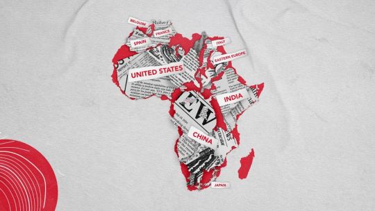
In Cape Town and Addis Ababa, the African Union supports Correct the Map, an initiative challenging map distortions of Africa. For centuries, the Mercator projection has shrunk Africa’s true size, making the continent appear comparable to Greenland—which is fourteen times smaller. With over 30 million square kilometers, Africa is larger than the United States, China, India, and much of Europe combined.
The project aims to adjust cartographic conventions and challenge deeper distortions in global perceptions of Africa’s importance. Academics note a “digital inflection point” where accurate mapping is increasingly feasible with satellite imagery and digital technology. However, shifting perceptions is a political issue, as consistently underrepresenting a continent can impact investment and global governance.
The Union plans to advocate for accurate maps within international institutions like the United Nations starting in 2025. While all maps involve some distortion, the initiative argues for responsible representation, and the work to fully implement accurate projections continues.
Surfaced by the Discovery lens — one of the vital signs ovr.news reads.
How we evaluated this
AI summary
read the original for the full story — Read on perfil.com . How we work →